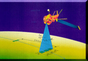
Infrared Sounders
Characteristics
Click on the links in the Name column to see more information about that instrument.
| Name | Orbit | Instr. type | Agency / Producer | Spectral range | resolving power | FOV | Sampling density | Power | Mass | Platform | Launch date |
|---|---|---|---|---|---|---|---|---|---|---|---|
| AIRS | 705 km | Grating | NASA JPL / LoMIRIS | 649-1135 1217-1613 2169-2674 | 1000- 1400 | 13×7 | 9 | 225 | 140 | Aqua | 2002 |
| CrIS | 824 km | FTS | IPO (DoD / NOAA / NASA) ITT | 650-1095 210-1750 2155-2550 | 900- 1800 | 14 | 9 | 86 | 81 | NPP and NPOESS C1 | NPP: 2010 C1: 2013 |
| IASI | 833 km | FTS | EUMETSAT / CNES Alcatel | Contiguous 645-2760 | 2000- 4000 | 12 | 4 | 200 | 230 | METOP -1,2,3 | 2006 |
| IRFS-2 | 850 km | FTS | Russian Aviation and Space Agency | 665-2000 | 2000 | 35 | 1 | 50 | 45-50 | METEOR 3M N2 | 2005 |
| GIFTS | Geo. | FTS | NASA / NOAA /Navy. Space Dynamics Lab. | 685-1130 1650-2250 | 2000 | 4 | 144 | 255 | 60 | Geostationary | ? |
| IMG | 797 km | FTS | NASDA / METI | 303-714 | 8 | < 150 | < 115 | ADEOS | 1996 |
Instrument descriptions
AIRS

The Atmospheric Infrared Sounder, AIRS, advances climate research and weather prediction into the 21st century. AIRS is one of six instruments onboard Aqua, a satellite that is part of NASA’s Earth Observing System. AIRS, along with two partner microwave sounding instruments, represents the most advanced atmospheric sounding system ever deployed in space. Together these instruments observe the global water and energy cycles, climate variation and trends, and the response of the climate system to increased greenhouse gases. The Atmospheric Infrared Sounder instrument is making highly accurate measurements of air temperature, humidity, clouds, and surface temperature. The data collected by AIRS is being used by scientists around the world to better understand weather and climate.
CrIS
The Cross-track Infrared Sounder (CrIS) is a Michelson interferometer infrared sounder designed to measure scene radiance and calculate the vertical distribution of temperature, moisture, and pressure in the Earth’s atmosphere. CrIS was designed to work in unison with the Advanced technology Microwave Sounder (ATMS), together they create the Cross-track Infrared Microwave Sounding Suite (CrIMSS). The objective of CrIMSS is to provide global three dimensional soundings of atmospheric temperature and moisture as well as provide data on other geophysical parameters. The Cross-track Infrared Sounder takes high spectral resolution measurements of Earth’s radiation to determine the vertical distribution of temperature, moisture, and pressure in the atmosphere. CrIS uses a Michelson interferometer infrared sounder covering the spectral range of approximately 3.9 microns to 15.4 microns (650-2550 cm^-1). It is the primary instrument for satisfying three Environmental Data Records (EDRs).
The Cross-track Infrared Sounder (CrIS) combined with the Advanced Technology Microwave Sounder (ATMS) globally produces atmospheric temperature, moisture and pressure profiles from space. CrIS and ATMS (CrIMSS) are the next generation operational sensor suite selected to fly on the National Polar-orbiting Operational Environmental Satellite System (NPOESS) spacecraft. Combining both cross-track infrared and microwave sensors aboard the NPOESS satellite provides key Environmental Data Records (EDRs) CrIMSS will operationally produce high vertical resolution profile measurements of temperature, water vapor, and pressure. In addition to providing operational temperature, moisture, and pressure profiles, CrIMSS has the potential to provide other surface and atmo- spheric science data, including total ozone and sea surface temperature. ATMS provides high spatial resolution microwave data to support temperature and humidity sounding generation in cloud covered conditions. In addition, ATMS provides advances in technology that allow the current operational temperature and moisture microwave sounder components to be packaged in one sensor with less total weight, power, and volume.
Additional information:
- CrIS: http://www.ipo.noaa.gov/Technology/cris_summary.html
- CrIS: http://jointmission.gsfc.nasa.gov/science/CrIScontent.REM.html
IASI
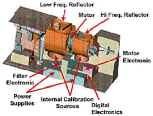
IASI is a spectrometer, that is an instrument that measures the spectral distribution of radiation. The instrument concept is based on the Michelson interferometer. Incident radiation is divided into two beams by a beamsplitter (A): the first beam follows a path of constant length (B); the other is reflected by a moving mirror and follows a path of variable length (C). The difference between both paths is called the optical path difference. The energy of the beams, when they recombine on the detector (D), varies with the path difference. It is maximum when the path difference is a multiple of the wavelength (beams in phase). It is zero when the path difference is an odd multiple of half the wavelength (beams in phase opposition). Energy on the detector thus varies with the movement of the corner cube mirror. This variation produces what is called an interferogram, which represents the Fourier transform of the spectral distribution of analysed radiation. The electrical signal from the detector is then digitized before performing a mathematical inverse Fourier transform to restitute the incident radiation spectrum.Additional information:
GIFTS
The Geosynchronous Imaging Fourier Transform Spectrometer (GIFTS) is a measurement concept which combines a number of advanced technologies, including particularly the Large area format Focal Plane detector Array (LFPA) with the Fourier Transform Spectrometer (FTS). The GIFTS will improve the observation of all three basic atmospheric state variables (temperature, moisture, and wind velocity) allowing much higher spatial, vertical, and temporal resolutions than is now achievable with currently operational Geosynchronous weather satellites. The displacement of the measured water vapor and cloud features will be used as tracers of the transport of atmospheric water as well as other important constituents (e.g., CO and O3). A key advance over current geostationary wind measurement capabilities is that the water-vapor winds will be altitude-resolved throughout the troposphere. Thus, GIFTS observations will lead to a significantly better understanding of weather and climate processes, including the atmosphere’s water cycle and the transport of greenhouse and pollutant gases.
The key to predicting the weather more accurately lies in measuring these atmospheric variables more accurately. Geosynchronous Imaging Fourier Transform Spectrometer (GIFTS) uses a new measurement concept that will provide the nearly continuous observation of large geographical areas with high, horizontal resolution. This concept combines the large area format focal plane detector arrays (LFPA) with the Fourier Transform spectrometer (FTS) on a geosynchronous satellite. The LFPAs and the FTS work together to make better observations and transform data more quickly, to more accurately predict weather and forecast air quality.
GIFTS will measure elements of the Earth’s atmosphere ( water vapor, wind, and temperature) and support space research aimed at reducing risks from severe weather. Secondarily, GIFTS will measure trace gases within the Earth’s troposphere and stratosphere, as well as the life cycle of clouds and their radiance and optical properties.Additional information:
- GIFTS:http://nmp.jpl.nasa.gov/eo3/
- GIFTS: http://oea.larc.nasa.gov/PAIS/GIFTS.html
- GIFTS:http://asd-www.larc.nasa.gov/GIFTS/
- GIFTS: http://www.ssec.wisc.edu/gifts/nasa/
- GIFTS: http://www.ssec.wisc.edu/gifts/noaa/
IMG
The Interferometric Monitor for Greenhouse Gases (IMG) is a sensor to monitor the earth’s radiation balance, the temperature profile of the atmosphere, the temperature of the earth’s surface, and physical properties of clouds. It was developed by the Japan Resources Observation System Organization (JAROS) for the Ministry of International Trade and Industry (MITI). IMG will obtain detailed spectra of thermal infrared radiation from the earth’s surface and atmosphere. The detailed spectra measured by the IMG will be used to infer atmospheric concentrations of water vapor and other greenhouse gases.